Historic Landmarks in Haddam
Route 154 (Saybrook Road)
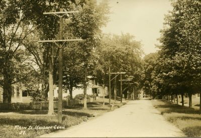 Stretching 9.2 miles north to south along the western bank of the Connecticut River through the town of Haddam, this byway is integral to the history of the town of Haddam and its villages of Higganum, Shailerville and Tylerville. Once a simple dirt path, the roadway was improved to a horse-drawn turnpike in the 19th century to a paved modern automobile highway in the early 20th century. The road itself has had many names: in the early years of settlement it was known as the "country road" or "ancient way."
In 1804 Middlesex Turnpike was opened and became the prime overland route from Hartford to Old Saybrook. The turnpike was a private toll road and tollhouses were located along the route to collect fares from travelers. The turnpike generally followed the road as it exists today except between the center of Haddam and the southern area of Higganum Village. The turnpike followed what is now called Walkley Hill Road. Middlesex Turnpike was a very active thoroughfare lined with taverns, stores, and other commercial establishments.
The late 19th century saw the introduction of the steam ship and the railroad through town and the county seat designation Haddam shared with Middletown was removed. Development along the turnpike started to slow down. However, the introduction of the automobile in the early 20th century gave the road new life and the road was renamed Route 9. Travelers continued to use it as the main road from Hartford to the Connecticut shoreline beaches.
In the late 1960s, the four-lane highway Route 9 was constructed to the west through the geographical center of the town; traffic on the historic road diminished dramatically. The road was designated as Route 154 and named Saybrook Road, also referred to as Old Route 9A. In 1994, the entire length of Route 154 was designated a state scenic road.
Bible Rock
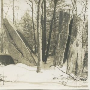 Located on the Haddam/Middletown border, this large approximately 14' high split rock looks like an open book. Set back about 125' from the west side of Route 154 it can only be seen when the leaves are off the trees. Location is 0.1 miles north of the Mattabesett Trail and entered from the main road from utility pole 3861. In 1941 Colonel Clarence S. Wadsworth left Bible Rock to the State Parks and Forest Commission.
Shopboard Rock
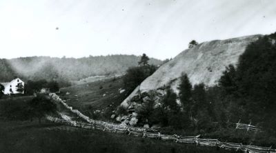 Standing 65' high and 75' wide, this "glacial erratic" is believed to be the largest free standing bolder in Southern New England. Located north of Higganum Village along the east side of Route 154, Shopboard Rock is mentioned in land records as early as 1711 and is said to have received its name from the fact that a tailor once cut a suit of clothes upon it for a customer whom he happened to meet there. The stream nearby is called Shopboard Stream.
Higganum Dike
Located on the west side of Saybrook Road (Route 154) near the intersection of Landing Road, this geological feature was formed about 200 million years ago when a deep split occurred in the earth's crust and was filled by hot material from the earth's core. The dike runs southwesterly towards New Haven and was exposed when improvements were made on the Route 154.
Scovil Hoe Buildings
A number of buildings survive in Higganum that are associated with the D & H Scovil Hoe Company. Founded in 1844 by brothers Daniel and Hezekiah Scovil, the Scovil Hoe Company was one of Higganum's most prosperous industries in the 19th century. Daniel, after touring the south and observing the methods and tools of the slaves in the cotton fields, developed the "planters hoe" and convinced his brother, Hezekiah to go into business with him. The innovative design of the Scovil Hoe, a self-sharpening tool with a softer outer edge over a harder steel core allowed the business to prosper and flourish. The Scovils thrived in business by achieving success in mass production, labor relations and marketing. They produced the "planters hoe" for over sixty years, supplying markets in the south and South America. During the Civil War they manufactured ramrods for area gun manufacturers. The business declined after the death of Hezekiah in 1904 but continued to manufacture hoes well into the 20th century.
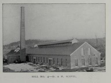 The D. & H. Scovil Company Mill No. 4 buildings along Candlewood Hill were built in the last half of the nineteenth century The older building located along Candlewood Hill Brook was erected in 1866 and is believed to incorporate an older mill building from 1838. The original mill on the site was used to grind feldspar quarried in Haddam Neck, pulverized and sent to porcelain factories in New Jersey and beyond. A second building was built in 1887. Both are constructed of brick and feature a clearstory monitor roof, a typical roof treatment for industrial buildings of this time period. The Scovil factory was sold in 1942 and the State of Connecticut converted it to a garage in 1945.
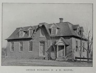 The D & H Scovil Company Office is located on Scovil Road off Candlewood Hill Road just beyond the Route 9 overpass. This Second-Empire style brick building was constructed in 1870 along Candlewood Brook.
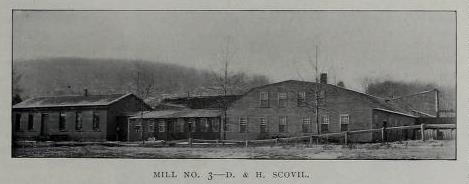 D & H Scovil Company Mill No. 3 stands directly across the street from the Scovil Office Building. The brothers Scovil purchased this site in 1867 with a factory and water privileges. A mill has been located on the property since the 1830s, using waterpower from Candlewood Hill Brook. The Scovils improved and added on to the mill and used it as a polishing shop.
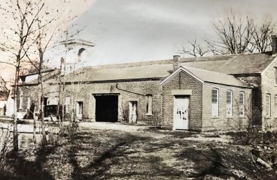 D & H. Scovil Company Mill No. 2 is located on the north side of Candlewood Hill Road and sits on the former site of Friend Dickinson's axe and chisel factory. Dickinson's heirs sold the mill to D. & H. Scovil in 1857, and they replaced it with the existing brick edifice. The factory was enlarged in 1860 and the new building was connected to the first by a 130' long wooden roofed bridge. In the 1930s the building was converted to a summer residence for Earl and Christine Benham, Broadway comedians. In 1964 the estate was sold to the Apostles of the Sacred Heart of Jesus.
Flag Rock
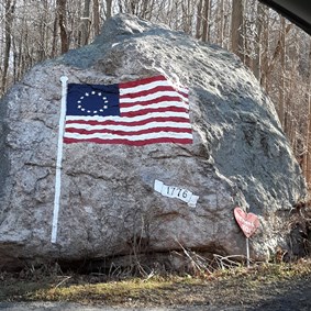 Originally known as Lorenzo Dow's Rock or Pulpit Rock, this large landmark is on the south side of Candlewood Hill Road near the intersection of Maple Avenue West Reverend Lorenzo Dow was a Methodist circuit rider preacher who is said to have preached on the rock in the 1790's, hence the name Pulpit Rock. In 1942 William Neff, who lived across the street, painted a large American Flag on the rock after Pearl Harbor was bombed. This symbol of local patriotism originally featured 48 stars and golden flagpole and tassels. In 1976 in honor of the bicentennial the flag was revised to feature the original 13 stars. The rock was maintained by members of the Neff Family until the early 21st century.
Candlewood Hill
Located on the north side of Candlewood Hill Road about a mile from Higganum Center, Candlewood Hill rises above the flood plain with a ridge covered in pitch pine. "Candlewood" comes from the knots of pitch pine, which Colonial era families burned for additional light. Candlewood was also used as kindling and splinters were used in place of the more expensive and valuable dipped candles.
Hezekiah Scovil Sr. House
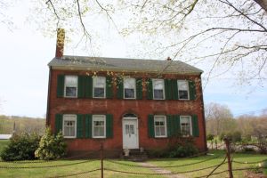 This prominent 1810 Federal style brick residence is located at the intersection of Candlewood Hill, Little City and Foot Hill Roads. Hezekiah Scovil was trained as a blacksmith and in 1809 started his own business across the road and manufactured hoes, hammers and other farming tools. He later worked with Eli Whitney of New Haven where he learned to weld gun barrels. Hezekiah converted his factory to make guns and he supplied the U.S. government with arms during the war of 1812. He built this house shortly after his marriage to Hannah Burr in 1811. His two sons, Daniel and Hezekiah Jr. founded the prosperous D & H Scovil Company, one of Higganum's most important 19th century industries. The uprights in the fence surrounding the house are said to have been made of gun barrels manufactured by Mr. Scovil.
Higganum Reservoir Dam
 The original dam (recently replaced by the State of Connecticut) was constructed in 1868 by brothers George M. and Thomas J. Clark of the Higganum Manufacturing Company. Their firm, later known as Clark Cutaway Harrow, one of Higganum's most successful industries, produced an extensive line of farm equipment including 400 types of plows, disk harrows, cider presses, hay spreaders and carriage jacks to name a few. The factory, located at the site of present empty Rossi lumberyard, was powered by water from the reservoir and Candlewood Hill and Bible Rock Brooks. The factory burned in the early 20th century but the dam and reservoir remained until its 2003 reconstruction as Higganum Reservoir State Park.
David and John Brainerd Marker
Located along the western side of Walkley Hill Road near the northern intersection of Route 154, this granite stone with marker honors David Brainerd an Indian missionary and his brother John Brainerd.
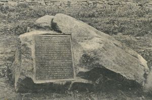 The marker reads "Opposite this spot was born, April 20, 1718 David Brainerd, A servant of God, wise in knowledge of men; self-forgetful in his devotion; of single hearted humility; careless of the dangers of the frontier, undismayed before failing health; he gave his brief manhood to the material and spiritual upbuilding of the Indians. He died at Northampton, Mass., Oct. 9, 1747. Here also was born, February 28, 1720 his brother and chosen successor, John Brainerd. A missionary of life-long zeal and unswerving fidelity; a chaplain in the French and Indian War; an honored trustee of Princeton College. He died at Deerfield, N.J., March 1781."
David Brainerd was a man of character and strength despite the hardships he faced early in life. Born in 1718, he had many brothers and sisters. His father, a member of the General Assembly, died when David was nine years old. His mother died four years later. From that time on, David lived with one or another of his siblings.
At nineteen, David tried his hand at farming in the hills of Durham, where he owned land. According to Eveline Warner Brainerd he soon gave up farming to pursue a different career. "But, student, mystic, teacher by nature, he did not fit to the pattern…. Not ill off according to the sparse standards of the time and place, he could choose, and he chose the ministry."
David turned his attention to Phineas Fiske, Haddam's minister (who had succeeded David's grandfather, Jeremiah Hobart.) His studies with Fiske came to an end when, a few months later the beloved minister died. He moved to Glastonbury to study under his brother Nehemiah, also a minister, until entering Yale that autumn. His education at Yale was cut short when he was expelled. His diary does not indicate why. According to Eveline Warner Brainerd, "All his journal tells, save of his heart rendering inward struggles and bitterness of spirit and despair is that he set himself to completing his studies, this time with Jeremiah Mills of Ripton. When his class was graduated, he who stood at its head, was prepared to take his degree with his classmates had the authorities been willing to accept his dignified yet touching sincere apology."
Despite his disgrace, he was ordained at Newark on June 12, 1744. Appointed by the Scotch Society for Propagation of Christian Knowledge, he took up dwelling on the forks of the Delaware River and from there began his missionary labors, preaching to the Indians in New York, New Jersey and Pennsylvania. On October 9, 1747, his body weak with illness, he died in Northampton. He was only twenty-nine.
The Hazenhurst Farm Barn
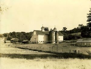 This magnificent structure was built in the early 1900s as the cow barn for Hazenhurst Farm. The cows would pass under Saybrook Road through a tunnel (now filled in) to reach the abundant pastures of Haddam Meadows. The building was demolished in August 2023.
Thankful Arnold House
See section on Thankful Arnold House for complete history and tour.
Haddam Gaol (Jail) and Workhouse
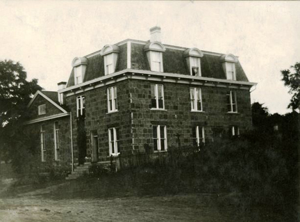 Prominently located at the intersection of Jail Hill Road and Saybrook Road, this imposing granite structure was constructed in three phases in 1845, 1855, and 1874. The original portion is the southern block with a fully pedimented gable end and load-bearing walls of solid stone 15 to 24 inches thick. The Second-Empire style addition from 1874 features a mansard roof with dormer windows.
When Haddam was designated a half-shire town in 1785, it was required to provide a courthouse and jail. The original jail was a wooden building erected in 1786 and stood on the southwest side of Jail Hill Road. In 1812 this building was condemned and a brick jail was constructed on the same site. In 1844, brothers Samuel, Jonathan and Isaac Arnold, owners of the successful Arnold granite quarry, were commissioned to "substantially erect, build, set up and finish a Gaol, in such a manner that it will answer the purpose of a Gaol and County Workhouse." Original specifications called for a stone "mansion" on the west end to provide living space for the jailkeeper on the first floor and locked rooms for debtors and female prisoners on the second floor. Each cell in the jail had 8 inch thick interior stone walls and floors were one solid stone laid 3 inches into the outer walls. The workhouse and barn were added in 1855. Prisoners, who helped erect the jail, were also allowed to work in town as farm, mill, and quarry laborers to earn their keep.
Although Middletown became the sole county seat in the 1890s, the jail continued to hold prisoners until 1969. In 1970 it was converted to the Correctional Facility for the State of Connecticut and was renamed the Connecticut Justice Academy.
Historical Marker: Location of First Meetinghouse
Located on the east side of Saybrook Road on private property, this plaque commemorates the location of Haddam's first Meetinghouse which stood on this site from 1674 to 1721. Colonial period Meetinghouses served many different purposes including public worship, church and town meetings, school meetings, courts, legislative assemblies and many other public gatherings.
Middlesex County Temporary Home
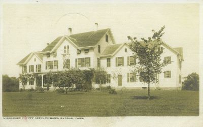 Erected in 1887 on Saybrook Road, the Middlesex County Reception Cottage and Temporary Home has been significantly altered from its original appearance. When built, the orphanage stood three stories tall with 2 ½ story wings on either side. From 1887 to 1954 the building served as the county temporary home. The building housed approximately 60 children who attended the local school and churches. The building to the north was purchased for use as the infirmary and is now a private home. When the orphanage closed the building was sold to the State of Connecticut which renovated it for use as the University of Connecticut's Agricultural Extension Service Center.
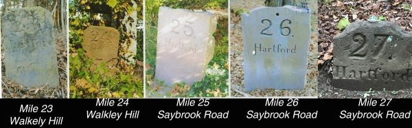
Mile Marker
Located on the east side of Saybrook Road across the street from the Park Road intersection, this replacement marker notes the distance to Hartford is 25 miles. Mile markers were located every mile along the Middlesex Turnpike indicating how far it was to the old courthouse on Main Street in Hartford. There is one found at Mile 27 near Camp Bethel Road and Miles 23 and 24 along Walkley Hill Road. Mile marker 22 in Higganum was recently damaged.
Goodspeed Station
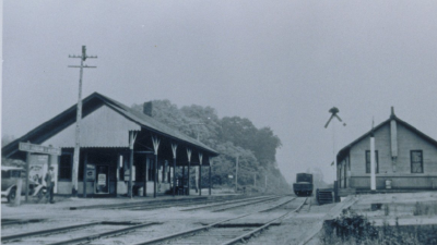 Now Goodspeed's Station County Store, this building was originally the freight house for the Goodspeed Station and was built in 1871. The Railroad Station was located on the west side of the track and no longer exists, although there is a small historic building approximating its location. The Connecticut Valley Rail Road opened in 1871 due in large part to the financial encouragement of Haddam resident James Walkley. The train ran from Saybrook to Hartford. Haddam had four stations, Higganum, Walkey, Haddam, Arnolds and Goodspeed. The Goodspeed Station was also known as East Haddam/Moodus. The train station was removed in 1932 after passenger service ended and freight trains stopped running in 1960s. This building, which was previously a feed and grain store, has been renovated as a gift shop.